Horses and Cattle to Be Removed from TRNP?

The Park Service is working on a new livestock management plan that will protect native species and the natural prairie ecosystem at the expense of nonnative horses and cattle, according to a story posted this evening by The Bismarck Tribune.

Not mentioned in the report:

An advocate interviewed for the story said all the horses can’t stay but maybe the Park Service can keep some of them.

You have to give them credit: They think alike.

“If we get rid of them, they can stay.”

RELATED: Advocates Criticize Treatment of Horses at TRNP.

Where Did All the AUMs Go?

Here is a map of southeastern Oregon and western Idaho, with layers added one by one, from the BLM National Data Viewer.  Click on image to open in new tab.

First, in gray, areas of critical environmental concern.

Second, in black, the HAs, lands identified for wild horses and burros.

Third, in orange, the HMAs, areas managed for wild horses and burros.

Fourth, in green, the grazing allotments, the #1 priority of rangeland management, obliterating everything else.

This is why you have 62,000 wild horses and burros in off-range holding and why the FY 2023 roundup schedule, not yet released, may top last year’s capture and removal targets.

Despite these results, the advocates continue to bash the drillers and miners, a small threat compared to permitted grazing, and push their ruinous darting programs.

The horses and burros don’t have a chance.

RELATED: The Carrying Capacity Puzzle.

Where Did All the AUMs Go 12-19-22

Colorado Permittee Sells Acreage to BLM?

A December 15 news release said the Grand Junction Field Office has acquired two parcels through the Land and Water Conservation Fund covering 1,600 acres in Mesa and Garfield counties, adjacent to the South Shale Ridge Area of Critical Environmental Concern and Little Book Cliffs Wild Horse Range.

Private land is shown in white on this map from the National Data Viewer.

BLM Colorado Land Acquisition 11-18-22

The Fund acquired the property from the Latham family and is now transferring it to the BLM, according to the announcement.

The Operator Information Report in RAS associates Authorization #0507007 with John R. Latham of De Beque.

The Allotment Information Report ties the authorization to the Dry Fork Allotment.

The Allotment Master Report puts it in the Maintain Category with 564 active AUMs on 10,973 public acres.

The allotment, not shown on the map, is a few miles north of the ACEC.

Although the selling price was not given, what other “good and valuable consideration” might come from the transaction?

  • Faster processing of permit renewals?
  • Greater flexibility in on and off dates?
  • Access to nonrenewable AUMs?
  • Minor problems overlooked?

Who knows!  Maybe it’s a different Latham.

But how are you supposed to be objective and even-handed in cases like this?

FY 2023 Roundup Schedule Inching Closer to Publication?

The stopgap spending bill signed yesterday, originally introduced as an amendment to the Weather Research and Forecasting Innovation Act of 2017, keeps the federal government running for another week, suggesting that the current Congress intends to produce a full-year spending package before the new Congress can be seated.

At that point, budgets for the DOI and BLM will be revealed and program expenditures can be set in motion.

Those figures are usually found in the Division G Explanatory Statement which accompanies the legislation.

The FY 2022 spending bill authorized a wild horse and burro task force, to be established within 90 days of enactment.

Western Horse Watchers has not seen any news releases about it.

RELATED: FY 2023 Roundup Schedule Delayed by Spending Bill?

Piceance Helicopter 08-06-22

Horses of Caisson Platoon Find New Pastures on BLM Land

Their official duty is to carry the nation’s military heroes to their final resting places at Arlington National Cemetery.

Caisson Platoon 12-17-22

Off-duty hours are spent in stables at Fort Myer and Fort Belvoir, Army bases south of Washington.

A BLM news release dated December 15 said the agency has granted the Army a temporary right-of-way to graze up to twelve horses on fourteen acres in the Meadowood Special Recreation Management Area near Lorton, VA.

The Proposed Action, described in a DNA worksheet, indicates an immediate need for interim pasture space due to renovations at Fort Belvoir that will take three to five years to complete.

The driver of the renovations was not given.

Caisson Platoon Land Map 12-17-22

A report by the Army’s Public Health Command-Atlantic, covered in an April 7 story by CNN, cited unsanitary and potentially life-threatening conditions at the facilities, with the horses consuming poor-quality feed, suffering from parasites and standing in tiny mud lots scattered with gravel and construction waste.

Two horses died unexpectedly in February.

The primary issues were lack of space, inadequate funding for improvements and routine turnover of the unit’s top leaders, according to the report.

Western Horses Watchers does not know if the renovations at Belvoir and the temporary housing at Meadowood were prompted by the findings.

The DNA worksheet was the only document posted to the project in ePlanning.

Opportunities for public involvement appear to be limited.

UPDATE: A story by Military dot com suggests the renovations and findings are related.

Leave Your Estate to the Wild Horse Advocates?

They could spend more time on the range pummeling the mares with their favorite pesticide and less time devising ways to separate you from your money.

New Pine Nut Calendar 11-19-22

Their mission is to help the bureaucrats enforce management plans that assign most of the resources to privately owned livestock in areas set aside for wild horses.

If you think they’re doing a good job and deserve a share of your estate, refer to this month’s episode of “Wild Horse Tales,” starting on page 13 in the December edition of Horse Tales.

Donations from ranchers and ranching sympathizers always accepted.

RELATED: The Trials and Tribulations of the Advocates

Are Roundups Safe?

Research over a ten-year period indicates a mortality rate of 1.7% for bait-trap gathers and 1.0% for helicopter gathers, according to an article by the Elko Daily Free Press.

Not mentioned in the story was the 5.9% death rate in the 2021 Jackson Mountains roundup, acute + chronic.

Criticism of roundups by the advocates is self-serving.  They don’t care if the horses have been cheated by the bureaucrats in favor of the ranchers.

CAAWH Ad on Google 11-26-22

Just give them a larger share of the wild horse removal market and greater use of a vaccine that causes illness instead of preventing it.

Perfect topic for Foal-Free Friday.

RELATED: Difference Between Helicopter Roundups and Darting Programs.

Standing Up for Wild Horses on Virginia Range 06-18-22

New Resource Enforcement Plan for Clan Alpine HMA?

A new project was created in ePlanning yesterday but no documents were posted.

The HMA covers 302,226 total acres in central Nevada, including 298,064 public acres.

The 979 horses allowed by plan require 11,748 AUMs per year.

The stocking rate allowed by plan is 3.3 wild horses per thousand acres, considerably higher than the target rate across all HMAs of one wild horse per thousand acres.

The estimated population as of March 1 was 1,944.

Clan Alpine HMA Map 12-15-22

The HMA overlaps three allotments, Cow Canyon on the west side, Clan Alpine on the east side and Dixie Valley on the south side.

The Allotment Master Report puts all three in the Improve category.

The allotments offer 15,038 active AUMs per year on 796,683 public acres, for a weighted average forage availability of 18.9 AUMs per year per thousand acres, enough to support an additional 1.5 wild horses per thousand acres.

Curiously, on a per acres basis, the horses receive twice as much forage as livestock, an outlier in the resource management process!

Virginia Range Crimefighting Update for December

The Nevada Board of Agriculture met today in Las Vegas.

The Animal Industry update was item 9 on the agenda.

The report indicated that 24 horse-vehicle collisions have occurred in 2022, compared to 27 in 2021 and 46 in 2020.

Wild Horse Connection continues to feed the horses in NDA approved locations to draw them away from highways and urban areas.

WHC Arrogance 08-13-21

The Campaign Against America’s Wild Horses, a leader in the wild horse removal industry, has delivered 941 doses of their favorite pesticide in FY23, including 221 primers and 720 boosters.

Crime in the Wild Horse World 05-26-22

With 77% of the injections being boosters, the program is moving into its final phase, and many of the mares will become sterile in another year or nearly so.

There is no hesitation.  They are not having second thoughts about what they are doing.

It’s balls to the wall to win the approval of the bureaucrats and ranchers.

RELATED: Virginia Range Crimefighting Efforts Paying Off?

For Your Innocent Ants and Roaches 10-23-22

Navigating the BLM National Data Viewer

Open the viewer, dismiss the splash screen and zoom/drag the map to the area you want to investigate.

In this example, the map has been scrolled to southwest Wyoming, the area affected by the Rock Springs RMP Amendments.

Click the layers icon to display the layer list.

Clear all of the check boxes except Wild Horse and Burro.

Expand the WHB layer by clicking the little triangle on the left.

By default, only HAs are displayed (black borders).

Navigating the National Data Viewer 12-14-22

If you put a check in the HMA box, the map will show the HMAs (orange borders).

Clear the HA check box if you only want to view the HMAs.

If you click on one of the polygons, a pop-up box will provide data for that area.

As noted yesterday, the black parcels denote land identified for wild horses and burros, while the orange areas represent those where horses and burros are still allowed—in small numbers, of course, relative to the available resources.

Scroll the list up and turn on the grazing allotments (green borders).

Now you know why there are 62,000 wild horses and burros in off-range holding.

The map tells you by visual inspection that roughly half of the land in this part of the state designated for horses and burros has been lost to permitted grazing, while the remainder has been subordinated to permitted grazing.

Has your favorite advocacy group explained any of this to you?

RELATED: Exploring the BLM National Data Viewer.

Exploring the BLM National Data Viewer

A downside of the Western Watersheds map is that it does not show the HAs, only the HMAs, but the National Data Viewer shows both, along with grazing allotments.

In this example, allotment boundaries are green, HMA boundaries are orange and HA boundaries are black.

If you click inside one of the polygons, a pop-up box takes you through the applicable land designations by hitting the little triangle in the upper right.

BLM National Data Viewer Example 12-13-22

Turns out that Campito’s old stomping ground, the Buckhorn HMA, and the adjacent Coppersmith HMA, are inside the Tuledad HA.

The HAs show you how much land was originally identified for wild horses and burros and the HMAs show you how much remains.

The New Ravendale horses have lost roughly half of their land, denoted by the orange parcel inside the black parcel that’s overlapped by the Ravendale AMP Allotment.

RELATED: How Many Wild Horses Can the Buckhorn HMA Support?

Assateague Census for December

The herd contained around 80 horses in 2016, when the safe, proven and reversible darting program was shut off.

If it was growing at a rate of 15% per year, the population should be about 185 now.

The herd size was 78 as of December 9, according to the Assateague Island Alliance, no change from October 5.

Does that mean the growth calculation is wrong?

No, it means the advocates are full of crap.

Why are you still giving them money?

RELATED: Assateague Herd Struggling in Latest Census.

PZP Dangers 10-21-22

How Many Wild Horses Can the Buckhorn HMA Support?

With the news of Campito’s passing, let’s take a look at resource management in his home range, which may explain why he and others were removed therefrom.

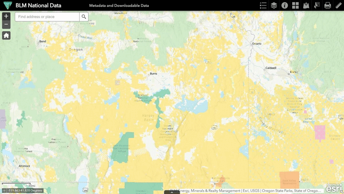
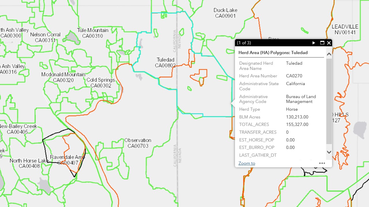
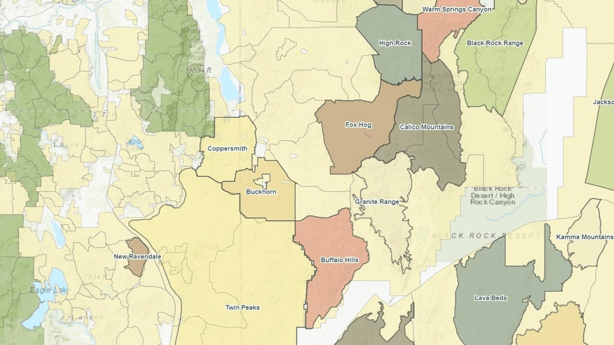
The Western Watersheds map indicates the Buckhorn and Coppersmith HMAs lie within the Tuledad Allotment.

The allotment represents food taken from the horses and given to livestock.

It likely predates the HMAs and should have been zeroed out to satisfy the “managed principally” requirement of the original statute.

Tuledad Allotment Map 12-11-22

The Buckhorn HMA covers 76,590 total acres, including 67,415 public acres, and the 85 horses allowed by plan require 1,020 AUMs per year.

Forage availability in this parcel works out to 15.1 AUMs per year per thousand public acres, enough to support 1.3 wild horses per thousand public acres.

The Coppersmith HMA covers 73,422 total acres, including 60,246 public acres, and the 75 horses allowed by plan require 900 AUMs per year.

The land in that parcel offers 14.9 AUMs per year per thousand public acres, enough to support 1.2 wild horses per thousand public acres.

The HA/HMA Report gives the estimated populations and acreage breakdowns as of March 1.

The weighted average forage availability across the two HMAs (sum of AUMs divided by sum of acres) is 15.0 AUMs per year per thousand public acres.

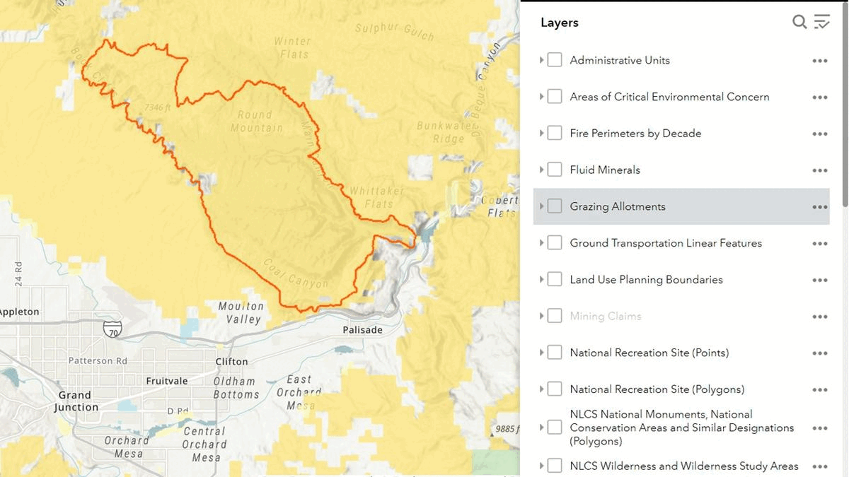
The Allotment Master Report provides information on the missing resources and answers questions about the actual carrying capacity of the HMAs.

The allotment covers 177,847 total acres, including 143,307 public acres, with ten pastures and eleven authorizations.

The Authorization Use Report shows the on and off dates.

With 7,406 active AUMs per year, forage availability in Tuledad is 51.7 AUMs per year per thousand public acres, enough to support 4.3 wild horses per thousand public acres.

So, Buckhorn should be able to sustain 1.3 + 4.3 = 5.6 wild horses per thousand public acres, for a True AML of 5.6 × 67,415 ÷ 1,000 = 377, 4.4 times higher than the current AML.

The current AML is small relative to the available resources because the HMA is managed primarily for livestock.

Even in the mid-90s, Campito and his herd were likely cheated by the bureaucrats in favor of the ranchers, as their progeny are today, leading to removal from their lawful home, probably by helicopter.

If the advocates were involved, they’d almost certainly demand removal by pesticide, making them complicit in the destruction.

Although the herd is currently at 3.2X AML, the last roundup in Buckhorn was in December 2009, suggesting the resources are adequate and the HMA can support many more horses than the BLM admits.

RELATED: The Carrying Capacity Puzzle.