An aerial count was carried out December 9 – 11 according to the Animal Industry Report for the March 19 Board of Agriculture meeting,
A BLM statistician is analyzing the data to provide a population estimate.
Western Horse Watchers Association
Exposing the Hypocrisy, Lies and Incompetence of the Wild Horse Advocates
On the range
An aerial count was carried out December 9 – 11 according to the Animal Industry Report for the March 19 Board of Agriculture meeting,
A BLM statistician is analyzing the data to provide a population estimate.
A 2020 post by the advocates explains habitat loss at the Salt River.
The prescribed course of action, which they were happy to fulfill, was to beat the numbers down with PZP until the population reached an acceptable size—even if it means sterilizing the mares.
How can that be good for the herd?
Why not start a war chest that could be used to buy a base property tied to one of the neighboring allotments and give the horses more space?
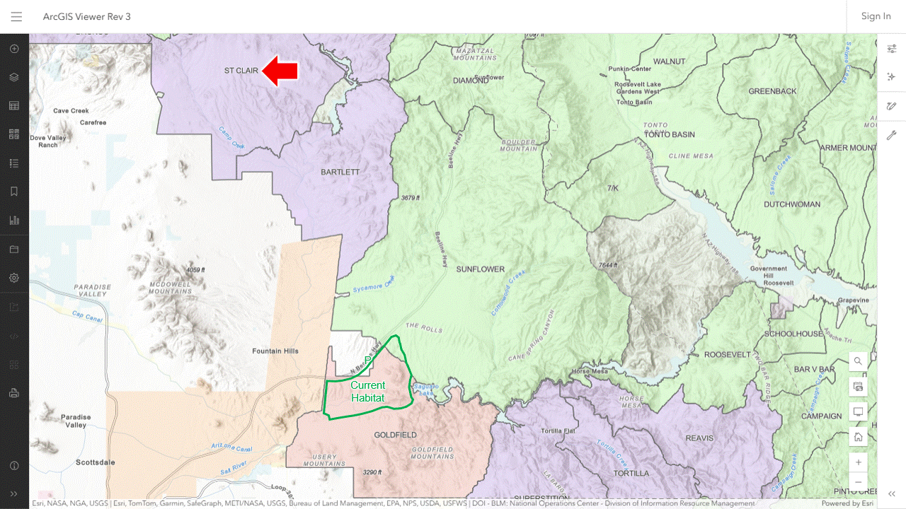
Appendix 5 in a 2018 report on forage availability said the Goldfield, Bartlett, St. Clair and Sunflower allotments were most similar in vegetation, soil and topography to the Salt River horse zone.
The horse zone is mostly in Goldfield, which has been closed to livestock grazing.
Sunflower contains Butcher Jones, one of areas where the horses roamed.
It is active while Bartlett and St. Clair are vacant.
Why don’t the advocates have their eyes on these parcels instead of the scopes of their darting rifles?
RELATED: Foal-Free Friday, Minimally Invasive Edition.
The resolution survived a roll call vote 11-1-2 in today’s hearing.
RELATED: SCR 4006 Hearing Next Week.
The current population, as of March 1, is thought to be 53,797 wild horses and 19,333 wild burros, compared to AMLs of 22,637 and 2,919, according to the new report.
The total number of HMAs has dropped to 175 from 177, as a result of the Rock Springs RMP Amendments, now under appeal.
Western Horse Watchers was unable to find an announcement at the BLM news site.
The report was posted to the Program Data page.
The facility report has not been updated since September but, as of today, there are probably more wild horses in off-range holding than on the range.
AMLs represent the number of animals allowed by plan, not the number of animals the land can support.
The first foal of the year has arrived according to a report by WTKR News.
The size of the herd and the number of mares ruined by the advocates are not known.
The bill was approved today by a vote of 56-8-1.
It has not been considered by the Senate.
RELATED: HB25-1283 Third Reading Set for Tomorrow.
The action was laid over from today.
The bill has picked up additional sponsors.
As of this evening, all responses for the March 20 hearing are “In Favor.”
RELATED: SCR 4006 Hearing Next Week.
Attorneys for the advocacy groups presented their claims to a panel of the Tenth Circuit this morning according to a report by Courthouse News Service.
Although three appeals were filed, the court consolidated them into one.
The panel did not indicate when it would rule.
The case centers around keeping wild horses off private lands, which, in this writer’s opinion, is not the government’s job in a fence-out state.
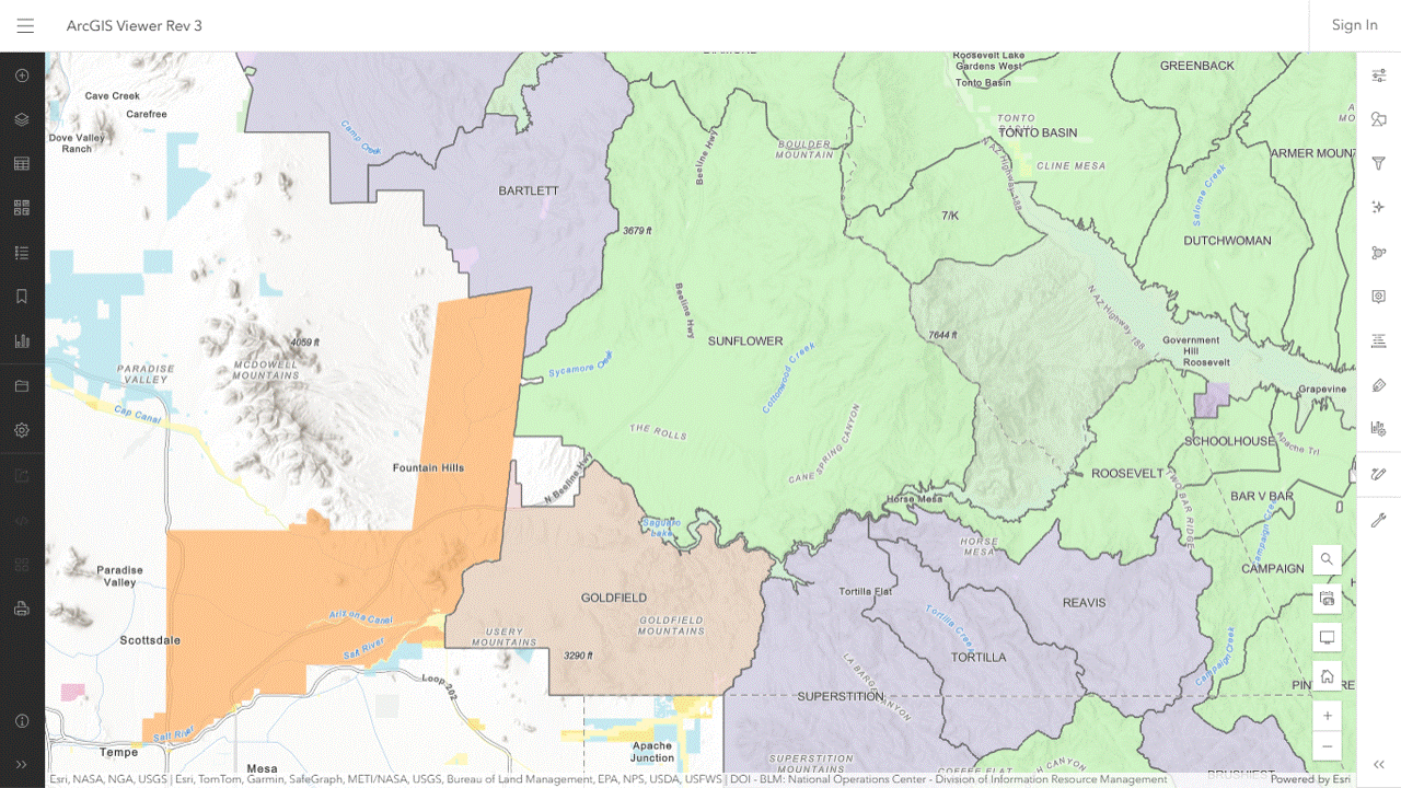
Appendix 5 in the 2018 report on forage availability said the Goldfield, Bartlett, St. Clair and Sunflower allotments are most similar in vegetation, soil and topography to the Salt River horse zone.
Bartlett and St. Clair are vacant according to the ArcGIS Viewer.
Together, they could support 617 wild horses.
Why aren’t the advocates in talks with the Forest Service to access those parcels?
The status of the base properties is unknown.
The protected habitat, described in the 2020 post, lies mostly in the Goldfield allotment but the northern end is in Sunflower.
RELATED: Repurposing Sunflower.

A new project created today has been marked Paused.
A similar project from November says In Progress but has no documents.
TRELATED; New Management Plan in the Works for Adobe Town HMA?
A 2020 post about the Salt River habitat explains why you can’t find any recent videos of wild horses at Butcher Jones: They were moved across the highway to another area.
The map refers to it as the protected habitat, shaded dark green.
The yellow, red and pink areas have been lost, although the yellow area may become accessible again if an overpass is built at Coon Bluff.
An eyeball estimate of the loss is forty to fifty percent of their land.
The pink area is referred to as the Butcher Jones Habitat, which the ArcGIS Viewer reveals as the Sunflower Allotment.
The stated reason for removal was access to water and conflicts with recreational use.
Were there other reasons?
A keyword search of the page yielded no results for Sunflower, allotment, livestock and permitted grazing.
The Forest Service has not posted the AOIs for the Tonto allotments but Table 1 in a 2018 report on forage availability indicated that Sunflower offered 10,020 AUMs on 158,000 acres, equivalent to 835 wild horses or 5.3 wild horses per thousand acres.
Why not start a fundraiser to purchase the base property tied to the allotment or at least the pastures where the horses roamed?
Then ask the Forest Service to change the preference to horses.
RELATED: Butcher Jones and Sunflower.
The allotment, located about 30 miles north of Casper, offers 569 active AUMs on 5,061 public acres according to the allotment master report.
It’s in the Improve category, suggesting that your stewards of the public lands are not taking their responsibilities seriously.
The management plan assigns zero AUMs to wild horses.
How many could live there?
The forage assigned to livestock is equivalent to 47 wild horses, or 9.3 per thousand public acres.
Why is this important?
Your faithful public servants claim that rangelands in the western U.S. can only support one wild horse per thousand acres (27,000 animals on 27 million acres).
The advocates give their assent through their darting programs.
If the allotment was an HMA, the AML would be 5 and 42 wild horses would be consigned to off-range holding because of permitted grazing.
BLM allotments in Wyoming support livestock equivalent to 158,425 wild horses on 17,312,214 public acres, or 9.2 wild horses per thousand public acres.
Wild horses can be placed on public lands not identified for their use by acquiring base properties associated with grazing allotments and flipping the preference to horses.
RELATED: The Allotments Tell the Story: They’re Lying, All of Them.

On the Salt River, site of the nation’s second largest wild horse sterilization program, with Mark Storto.
In chapter four of Wild Horse Annie and the Last of the Mustangs, authors David Cruise and Alison Griffiths date her first encounter with the horse runners to a spring morning in 1950, meaning the event which launched modern-day advocacy is now 75 years old.
“What she saw on that truck was beyond anything she’d ever experienced.”
RELATED: Diamond Anniversary of Wild Horse Preservation Movement.
Key moments in this video from late 2022:
Missing from the video are wild horses, who may not be able to access the area anymore.
RELATED: Wild Horses at Butcher Jones.
A listing on Zillow gives the address of a 40-acre parcel in Storey County as 40 SW 4nw4 S 16/18n/21e LOT 12S, Reno, NV 89521.

The map puts it on Sazarac Rd which is wrong.
The callouts for these properties should be read from right to left.
The first part tells you it’s in Section 16 of Township 18 North, Range 21 East.
The township-range blocks typically consist of 36 sections covering one square mile each. The sections usually contain sixteen 40-acre parcels.
Zoom the viewer to the Reno area, turn on the Public Land Survey System layer and look for 18N 21E.
Zoom in on that block and look for Section 16.
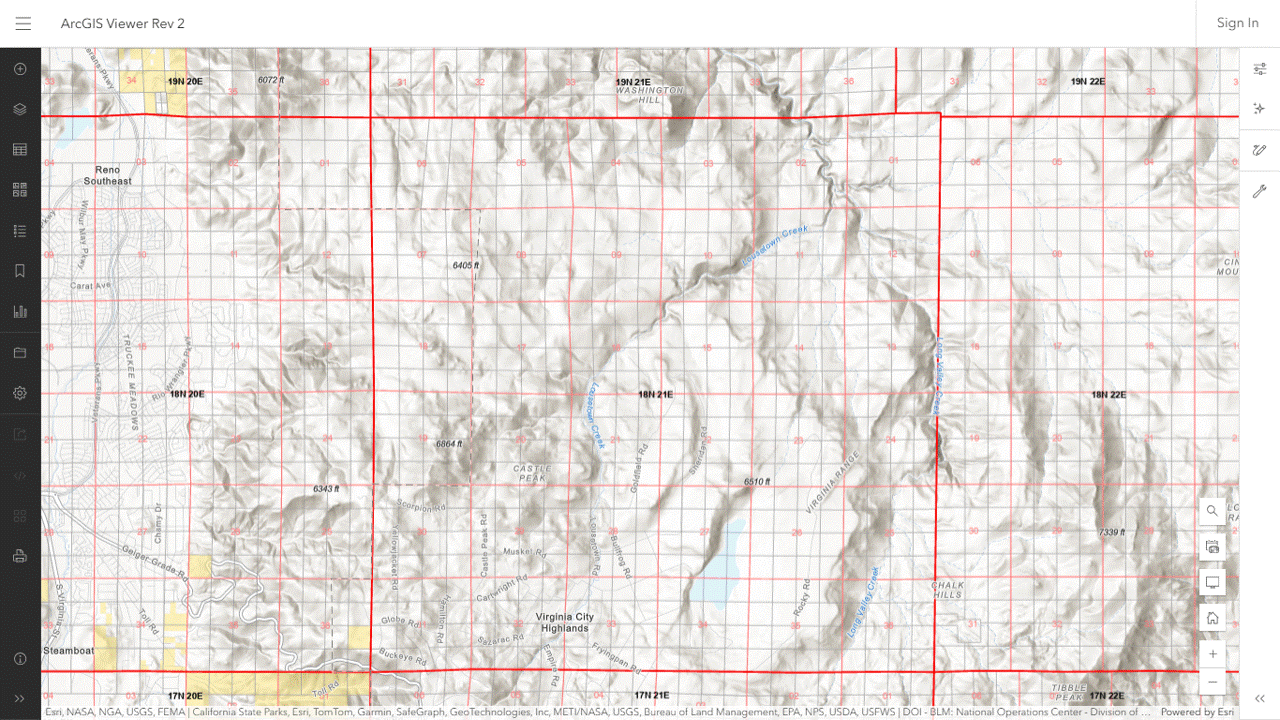
Zoom in on Section 16.

The section can be divided into four quarters, each one containing four lots.
Lousetown Creek flows through it, probably from the southwest to northeast.
The listing tells you it’s the southwest lot in the northwest quarter.

The photo tells you it’s on the Virginia Range.
These parcels, although very remote, are zoned as single-family residences.
A management evaluation has been copied to the project folder for public review.
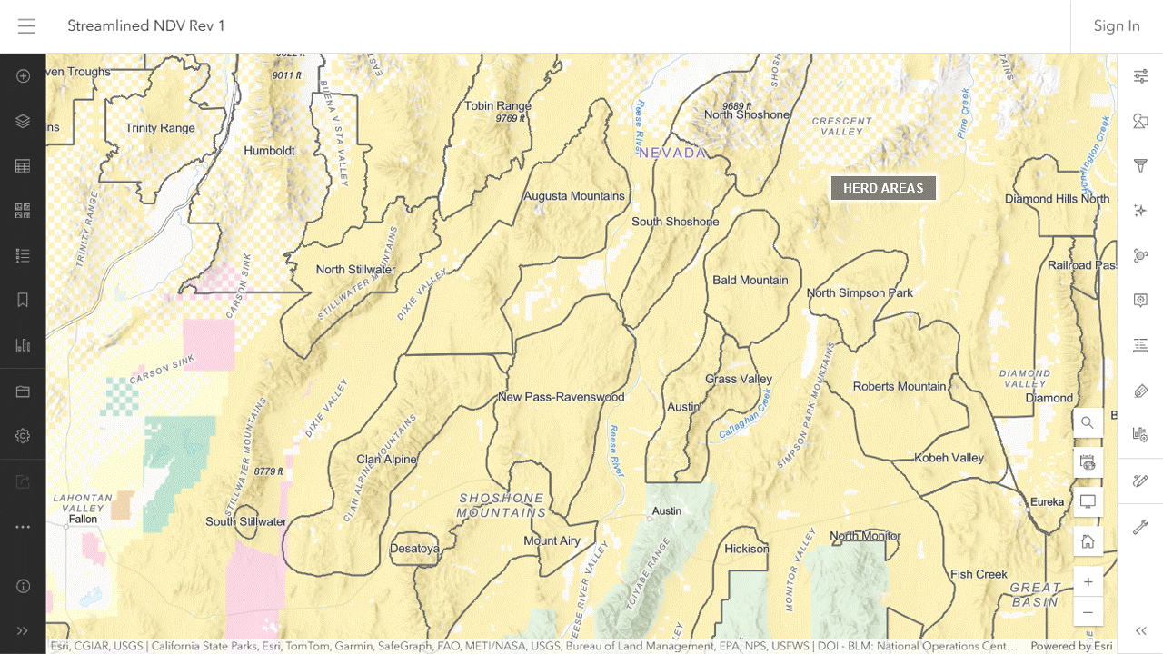
The Complex consists of the Bald Mountain, Callaghan, South Shoshone and northern end of the Hickison HMAs, as well as the North Shoshone HA.
The HA has been zeroed out and will be omitted from the analysis.
The HMAs are subject to permitted grazing.
Comments will be accepted through April 14.
The HMAP will ratify and reinforce resource allocations already on the books.
If the Complex was managed primarily for livestock before the project, it will be managed primarily for livestock after the project.
The House Agriculture Committee will consider the resolution on March 20.
The deadline to submit testimony is 7:00 AM.
RELATED: SCR 4006 Introduced in House.

