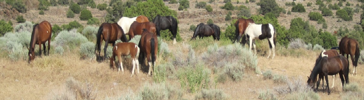
Virginia Range Mustangs Graze Near Carson City Airport

They found some snow-covered grass on College Parkway, according to a story posted yesterday by Carson Now.  Includes photos.

A commenter said it was “Part of the heritage and charm of living in Northern Nevada.”

Couldn’t agree more.

Sometimes the horses can be found by taking Goni Road north, into the hills.

They also graze in and around Centennial Park, east of the airport.

Carson City Airport Map-1

Comments Invited on Reveille Gather Plan

BLM announced on Thursday the opening of a 30-day comment period on a preliminary Environmental Assessment for gathering and removing excess horses on the Reveille HMA in central Nevada.

The HMA covers 105,494 acres and has an AML of 138, for an aimed-at population density of 1.3 wild horses per thousand acres.  The target density across all HMAs is one animal per thousand acres.

Reveille HMA Map-1

The Reveille HA, marked red in the map above, contains the HMA.  Horses were found there in 1971 but the land is no longer managed for them.

The HA and HMA lie within the 650,520 acre Reveille Allotment.  See Map 2 in the EA.

One permittee, who grazes the entire allotment, receives 25,730 AUMs per year from the BLM, per Section 3.2.4 in the EA.

The HMA intersects roughly 16% of the allotment (105,494 ÷ 650,520), suggesting that an additional 4,173 AUMs per year are available in that area, but have been assigned to livestock, with a twelve month grazing season.  See Table 1 in Appendix F of the EA.

The management plan allocates 1,656 AUMs per year to horses in the HMA, according to Section 1.5 (138 × 12).

The livestock AUMs convert to 348 cow/calf pairs, with a population density of 3.3 cow/calf pairs per thousand acres.

Reveille Calcs-1

These figures are presented in the following charts.

Reveille Charts-1

Appendix F states that 2,210 AUMs were allocated to livestock in the HMA, about half of the amount estimated above.

The BLM has limited flexibility in managing wild horses in the HMA, due to a court order that requires roundups whenever the herd size exceeds AML.  Refer to Section 1.3 of the EA and Section 1.4 in the Supplemental Information Report.  The case was brought by the PLR mentioned above.

Comments on the gather plan can be submitted at this page.

Results Pending for Assateague Pregnancy Tests

Field work is complete, according to a report posted yesterday by the Maryland Coast Dispatch, with findings expected later this month.

Last month, a member of the WHBAB pointed to the herd, on the Maryland side of the island, as the gold standard for wild horse management, even though its size declined from 78 in November 2018 to 75 in November 2019 and its sex ratio is far from normal.

RELATED: Baby Boom Next Year on Assateague Island?

Book Tells Story of Shannon County Wild Filly

Fifty wild horses are allowed by law to inhabit the Ozark National Scenic Riverways in southern Missouri, so every year, some of them are gathered and offered for adoption.

“Shawnee, Wild and Tame” chronicles the first year of a filly born in January, 2018.

Although the foal is the central character, the author thought the book would be a good way to tell the story of all the wild horses living near the Current and Jacks Fork rivers, according to a report posted today by The Salem News of Salem, MO.

Park Service Seeks Volunteers for ‘Pony Patrol’

Here’s your chance to become an ambassador for the Banker Horses.  You must be at least 18 years old and able to walk the beach for a four hour shift, once a week.

Openings exist at Shackleford Banks and Rachel Carson Reserve.

Refer to this story by WTVD News of Raleigh-Durham, NC for more information.

UPDATE: See also this news release from NPS.  Includes link to online application.

Comments Invited on Southern Nevada Nuisance Gather Plan

BLM announced earlier this week the opening of a 30-day comment period on a draft Environmental Assessment for a ten-year plan to remove wild horses and burros in southern Nevada that feed near highways, creating a public safety hazard, or have strayed from their home range onto to private property.

The six HMAs affected by the proposal are highlighted in the following map.

Southern Nevada Gather Plan EA-1

The roundups will not be used as a means for achieving AMLs, according to the news release.  A similar statement appears on page 11 in the EA.

But they could be carried out on an emergency basis.  The meaning of the term and the rules that would be altered or skipped in those cases were not explained.

The resource assessment, summarized in Table 3-1 of the EA, says livestock grazing does not occur on [public lands] within or near the affected HMAs but does not indicate if it happens on private lands that may abut or lie in close proximity to the HMAs.

Given that wild horses and burros are not privately owned and are not considered to be livestock, do they lose their protected status when they exit federal lands and become subject to state and local laws for domestic livestock?  Probably not.

If Nevada is a fence-out state, should private property impacts be part of the analysis?

In cases where land owners have built fences to keep the horses and burros out, do the requirements of NRS 569.431 apply?

Comments can be submitted at this page.  Public input will be reviewed by BLM staff and responses will be included in the final EA.

High Capacity Adoption Center Coming to Wyoming?

The facility would be located on an 80 acre farm near Burns and could hold 5,000 excess horses, according to a story appearing today in the Pine Bluffs Post.

Residents within a three mile radius must agree with the idea, per current rules, and so far the applicant has failed to win their support.

The facility would fill quickly if the disastrous ‘Path Forward‘ is implemented.

Desatoya Herd to Be Rightsized Starting Next Week

BLM said today that 431 excess wild horses will be removed from the Desatoya HMA, starting on December 4.  The operation will be carried out with helicopters and will be open to public observation.

The roundup will restore a thriving ecological balance and multiple-use relationship on public lands, according to the news release.

The HMA covers 161,678 acres in central Nevada an has an AML of 180, for an aimed-at population density of 1.1 horses per thousand acres.

Desatoya HMA Map A-1

Captured animals will be taken to the off-range corrals at Palomino Valley, about 20 miles north of Sparks, NV.

Section 3.7 in the Environmental Assessment suggests that permitted livestock grazing occurs in and around the HMA, but there is not enough information for a comparison of horse AUMs to cattle AUMs within the HMA.

Gather stats and daily reports will be posted to this page.

UPDATE: Map 2 in Appendix G shows that the HMA intersects four grazing allotments: Clan Alpine, Edwards Creek, Porter Canyon and South Smith Creek.  As usual, the AUMs offered to the poor ranchers far exceed the crumbs allocated to the horses.

Penn’s Cabin in the News

Restoration of the old cabin visited by Ginger Kathrens in the Cloud documentary began this summer and will carry over into next year, according to a story posted today by the Billings Gazette.

Its owner, Perrin Leander Cummings, died at the age of 26 in an accident involving wild horses.  He was better known by the nickname ‘Penn.’

The land on which the cabin was built is now part of the Pryor Mountains WHR.

Comments Invited on Scope of Rock Springs Gather Plan

BLM announced yesterday the opening of a thirty day comment period on a the scope of a proposed plan for managing wild horses on five HMAs in the Wyoming Checkerboard, a patchwork quilt of public and private lands along the I-80 corridor in southern part of the state.

Affected HMAs include Adobe Town, Divide Basin, Little ColoradoSalt Wells Creek and White Mountain, home of the Pilot Butte Wild Horse Scenic Tour.

Rock Springs HMA Map-1

Public comments are the first step in preparing an Environmental Assessment for a proposed action, according to the scoping statement.

Roundups in this area are driven by the infamous Rock Springs consent decree, a court order resulting from legal action by the Rock Springs Grazing Association.

The scoping documents include maps of the HMAs but do not provide any information on domestic livestock grazing, such as the number and size of the allotments, permitted AUMs and grazing seasons.  Those figures will likely appear in the draft EA.