BLM Issues CX for Red Rock Lakes Wild Horse Removal

NEPA analysis is not necessary according to the Decision Record.

In the latest incident, wild horses moved onto private lands, breaking through fences and eating hay stored in pole barns.

The project description says they’re leaving the HMA due to insufficient food and water.

The ArcGIS Viewer indicates it’s subject to permitted grazing.

The agency did not indicate if California is a fence-out state.

A roundup does not appear on the latest schedule but may fall into the “Unassigned” category of the Emergency/Nuisance section.

Red Rock Lakes HMA with Allotments 03-13-25

HB25-1283 Financial Impact Statement Released

The bill requires an appropriation of $555,000 in FY 2025-26 to help manage the state’s wild horse population according to the statement.

It allows the Department of Agriculture to start an immunocontraception program and creates a wild horse advisory committee.

Funding for a wild horse preserve was not discussed.

RELATED: Colorado Wild Horse Working Group Supports HB25-1283?

Mares Run the Show at Wild Horse Refuge?

It’s a nonreproducing herd, and the males are actually geldings, but an article by the Craig Press refers to them as stallions.

“While the stallions are the big flashy ones that do all the big bites and everything, it’s those older mares that are really the bosses, and nobody crosses the boss mare.”

That might be true at the refuge but it’s not true in the wild, despite all the fairy tales you’ve heard from the advocates.

Problem is, it’s getting harder and harder to find herds that are truly wild.

Many in the public eye, especially those chronicled on socialist media, have been decimated by the government or ruined by the advocates.

To its credit, the refuge is based on the right concept—purchasing a base property and flipping the preference to horses—but the numbers fall short of the ideals.

RELATED: How Does Wild Horse Refuge Rate as a Wild Horse Refuge?

ArcGIS Viewer Update

Added two layers to the map and saved it as Rev 1:

  • USFS Wild Horse and Burro Territories (not visible by default)
  • USFS Grazing Allotments (not visible)

The territories are not active at the default zoom level.  Click the Zoom In button to activate them.  Then click the visibility icon next to the layer name to see them.

A blinking dot on the left side of the visibility icon means the layer is loading.

Territory labels may require additional zooming.

The Legend toolbar button (on the left margin) explains the color codes.

RELATED; Streamlined NDV Replacement.

ArcGIS Viewer Rev 1 03-08-25

BLM Issues Montgomery Pass Final Planning Documents

The Decision Record authorizes the Proposed Action, discussed in Section 2.2 of the Final EA, which calls for wild horse removal by helicopter or bait.

Map 1 in Appendix 1 shows the project area.

All documents have been copied to the project folder.

There are no plans to treat any of the mares with fertility control pesticides and return them to the range.

A roundup does not appear on the latest schedule.

The news release said that appeals can be submitted through April 7.

RELATED: Montgomery Pass EA Out for Public Review.

Foal-Free Friday, Halting the Helicopters Edition

Liberals view reproduction as a defect of nature, an illness to be cured, not a vital part of existence and gift from God.

Thus, their obsession with abortion, contraception and sterilization.

They project these evils onto wild horses as a humane solution to a man-made problem, furthering the ranching agenda.

Halt the Helicopters 03-06-25

Their followers line up like clapping seals.

Don’t be fooled by their propaganda.

They are public enemy #1 of America’s wild horses.

RELATED; Foal-Free Friday, Backstopping the Advocates Edition.

Pancake Gather Plan

Streamlined NDV Replacement

You do not need an ArcGIS account to use the new viewer.

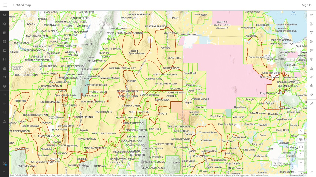
The default basemap is:

  • Terrain with Labels

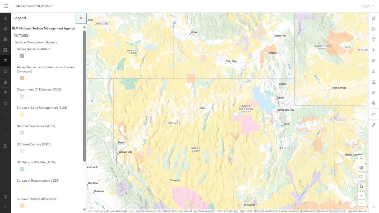
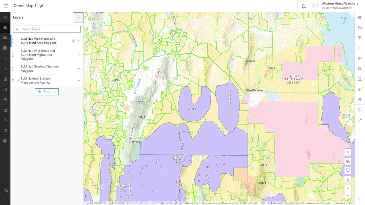
Four layers were included:

  • BLM National Surface Management Agency (visible when you open it)
  • BLM Natl Grazing Allotment Polygons (not visible)
  • BLM Natl Wild Horse and Burro Herd Area Polygons (not visible)
  • BLM Natl Wild Horse and Burro Herd Mgmt Area Polygons (not visible)

A legend appears initially, which you can toggle on and off with the Legend toolbar button on the left side of the map.

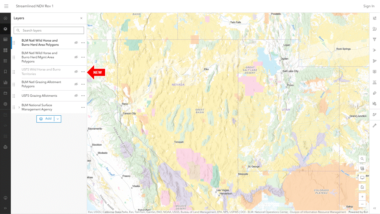
The Layers button toggles the layer list on and off.

To turn on the allotment layer, click the visibility icon next to the layer name (looks like an eye).  Click it again to turn it off.

Same for the other layers.

The Zoom buttons are at the lower right.

Drag the map to see other areas.

The Search button, also on the lower right, moves the map to a town or other landmark you specify.

Click the Home button to restore it to the original view.

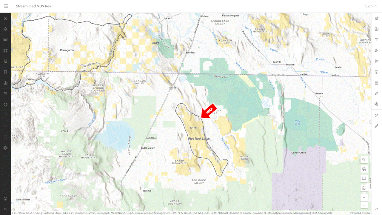
Click on an allotment or HMA to see basic information about the parcel.

RELATED: Creating an Account for the NDV Workaround.

Streamlined NDV Replacement 03-06-25

Creating an Account for the NDV Workaround

Go to the ERSI accounts page and click on Create an ArcGIS Public Account, where you’ll be prompted to supply your name and email address.

A confirmation email will be sent to your inbox.

Click on the link to set up a username and password.

Then go back to the map viewer.  Sign in if you want to save maps you create.

The system gives them URLs, which you can share with others.

For example, here is a map of allotments and HMAs along the NV-UT state line, using the default colors and styles.

RELATED: NDV Workaround.

UPDATE: Sharing of the demo map above has been set to public, link should work now.

ArcGIS Demo Map 1 03-06-25

NDV Workaround

This resource might be a suitable alternative to the National Data Viewer, which now requires a login.

Recommended basemap:

  • Terrain with Labels

Essential layers:

  • BLM National Surface Management Agency
  • BLM Natl Grazing Allotment Polygons
  • BLM Natl Wild Horse and Burro Herd Area Polygons
  • BLM Natl Wild Horse and Burro Herd Mgmt Area Polygons

Each layer has customizable properties, such as labels and outline and fill colors.

RELATED: BLM Puts NDV Off Limits?

NDV Workaround 03-05-25

BLM Releases Pancake Final Planning Documents

The Decision Record, copied to the project folder today, authorizes Alternatives A and D of the Final EA, minus the use of IUDs.  Refer to Sections 2.4 and 2.7.

The new plan supports three tenets of rangeland management.

The new HMAP is discussed in Appendix XIII.

The news release did not mention that the EA still refers to outdated registrations for GonaCon Equine, despite public comments.

RELATED: EA for Pancake HMAP Out for Public Review.

Pancake Comment on GonaCon Registration 03-04-25

Court Halts AIP

In his March 3 opinion, District Judge William Martinez agreed with petitioners that Instruction Memorandum 2022-014, which outline policies and procedures for administering the Adoption Incentive Program, violated the procedural and substantive requirements of the Administrative Procedures Act and that the respondents violated the National Environmental Policy Act by failing to evaluate the environmental impacts of the IM before putting it into effect.

The court vacated the IM and remanded it back to the BLM for further proceedings consistent with the ruling.

RELATED: AIP Lawsuit Moved to Colorado.

NOTE: If you can’t access the decision, click here.